Day 3: Where’s Your AQI Coming From? - Air Quality Awareness Week 2020
(For Air Quality Awareness Week 2020, we’re encouraging you to check the Air Quality Index (AQI) to decide when it’s best to be active outdoors. Check back each day for a new blog about air quality and your health. See part 1, part 2, )
What is the Air Quality Index, and why is it useful?
The Air Quality Index (AQI) is a tool public agencies use to report daily air quality, and it is derived from real-time measurements. The AQI helps the public understand what local air quality means for their health. At NDEP, our goal is to promote air quality awareness and encourage our communities to check the AQI to decide when it’s best to be active outside.
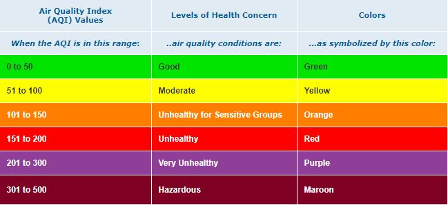
For clarity and accessibility, the AQI is divided into six levels of health concern: good, moderate, unhealthy for sensitive groups, unhealthy, very unhealthy, and hazardous. As part of this effort, environmental scientists at the Nevada Division of Environmental Protection (NDEP) issue air quality forecasts every day to help Nevadans and visitors plan their outdoor adventures. Scientists in Washoe and Clark Counties issue similar daily air quality forecasts. These forecasts are published on the AirNow website and are distributed through EnviroFlash.
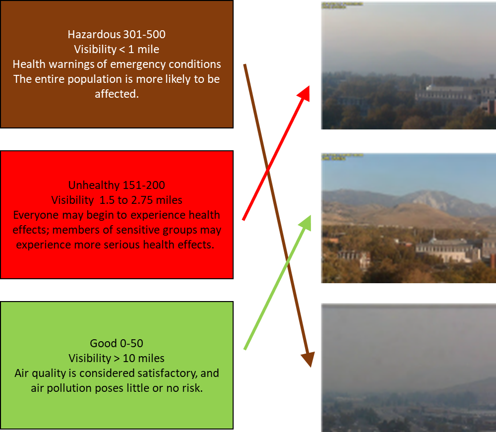
Here’s a short activity that gives an idea of what it looks like outside when our air quality is affected by air pollution. The pictures are of Mt. Rose, and were taken during the Rim Fire in 2014. See if you can match the pictures with the description of the air quality when they were taken. Check your answers at the bottom of this page.
Estimating Air Quality Using Visibility
We can use the visibility of objects to give us an idea of how good or bad the air quality is. Draw a line from the colored AQI range to the picture that matches best.

How do we calculate the AQI?
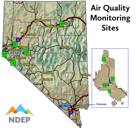
Every time you go online to check the air quality in your community, you’re tapping into a network of specialized sensors placed across Nevada. From Pahrump to Elko to Carson City, air quality monitors give us insight into the air outside, constantly documenting pollution concentrations throughout the day.
But it takes intentionality to make such important data available on your personal phone or laptop. Environmental scientists at NDEP use raw data from these sensors to calculate air quality, like today’s forecast. It’s a task that involves long drives across the state to make sure Nevada’s sensors are in top shape. And it requires careful collection and storage of data — lot’s of it.
These are the locations of Nevada’s air quality monitoring stations.
Keep reading to learn more about what Nevada is doing to monitor the quality of our air.
Why aren’t Reno and Las Vegas on the map?
Washoe and Clark counties maintain their own networks of sensors to measure air pollution, producing AQIs for areas around Reno and Las Vegas and, like NDEP, publishing them on the AirNow website and EnviroFlash.
Why isn’t there an air quality site in my community?
NDEP keeps air quality sites in communities with the highest populations and with historically poor air quality. But we use other methods to support rural communities too:
Visibility. We estimate air quality by observing the visibility of local landmarks like mountains or large buildings. When the sky is smoky, distant (or even nearby) objects can vanish — sometimes completely. How far we can see tells us something about the quality of the air.
Portable and personal air sensors. Portable and inexpensive, personal air sensors are becoming common and accessible to the public. NDEP has implemented a program to loan portable and personal sensors to communities that are being impacted by wildfires. Portable air sensors aren’t as precise as our official, regulated sensors. But with a little practice, portable and personal air sensors can provide meaningful, real-time data.
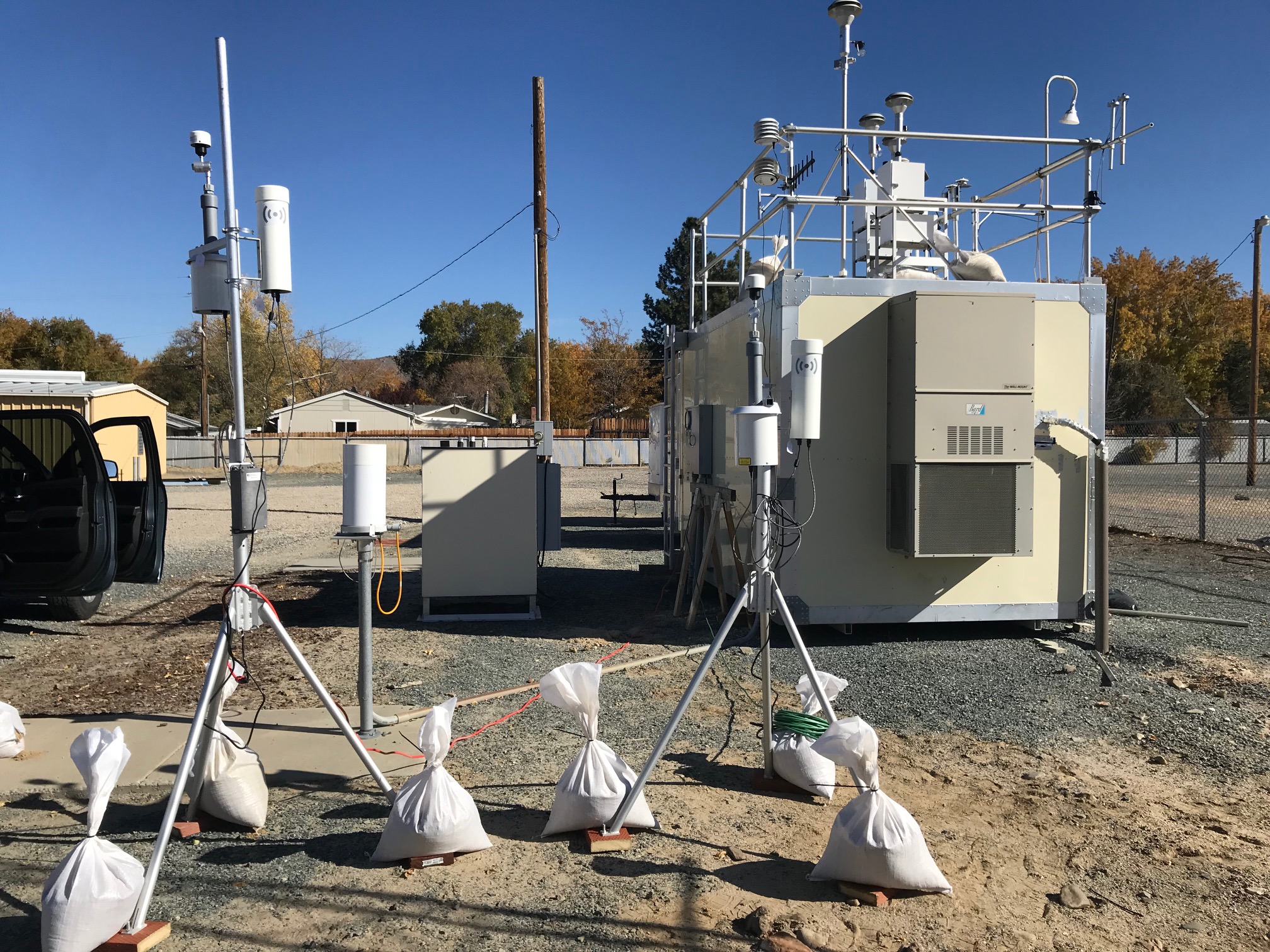
Portable air sensors (in the foreground) can be used in rural communities during smoke events. The larger unit in the back is a permanent station — part of a statewide network of air quality sensors.
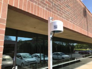
Personal sensors like this one can also be used in rural communities during air pollution events. Contact NDEP Smoke Management Program staff for more information about our personal air sensor loan program.
How’s the Air in Your Community?
Get near real-time air quality data on your device
Learn more about the AQI and how your health may be affected by poor air quality
For more information about the AQI and your health, check out these other great resources.
- A Guide to Air Quality and Your Health
- Centers for Disease Control and Prevention – Air Quality
- Healthy Heart Toolkit and Research
- Older Adults and Air Quality
Learn More About Nevada and Air Quality
Did you correctly match the pollution pictures with the description of the air quality? Check your answers below:
Estimating Air Quality Using Visibility
We can use the visibility of objects to give us an idea of how good or bad the air quality is. Draw a line from the colored AQI range to the picture that matches best.
Answer Key