New map platform enhances efforts to protect the state’s most sensitive plant and wildlife species
Carson City, NV - It’s a new era for wildland conservation. In Nevada, taking a proactive, science-driven approach to inform habitat conservation and management decisions is the foremost priority of the Nevada Division of Natural Heritage (NDNH). As part of these efforts, NDNH, in collaboration with the U.S.-based nonprofit NatureServe, is excited to unveil the Nevada Map of Biodiversity Importance, a smart-technology platform providing the latest scientific intel to help guide key strategies for the protection of the state’s most vulnerable plant and animal species.
From the unique flowering plants that contribute to Nevada’s ecosystems to the bumblebees and butterflies that pollinate them, this revolutionary map reflects Nevada’s diverse range of sensitive plants and animals. The map brings together innovative machine-learning technology with decades of field data collected by hundreds of ecologists, botanists, and zoologists to showcase populations of native plant and wildlife species that reside in areas which lack formally established habitat protections.
This critical data can be leveraged by local communities, agencies, and businesses to better understand the natural resources around them and assist in ensuring the long-term health and diversity of Nevada’s vital ecosystems.
“With more than 350 native species that live exclusively in the Silver State, Nevada is home to some of the most unique and diverse plant and animal species in the world,” said Kristin Szabo, Administrator of the Nevada Division of Natural Heritage. “As part of our mission, the Nevada Division of Natural Heritage is committed to providing science-based biodiversity data to ensure informed conservation and land-use planning decisions. I want to compliment NatureServe on their forward-looking approach to exhibiting biodiversity data as a step in supporting Nevada-wide habitat management.”
For over 34 years, NDNH has served as the official source of biodiversity information in Nevada. The new map program draws on this extensive data and Nevada-specific knowledge. When coupled with the resources and expertise of NatureServe, Esri, The Nature Conservancy, and Microsoft’s AI for Earth program, biodiversity data is transformed into an instrument that inspires on-the-ground action for habitat protection.
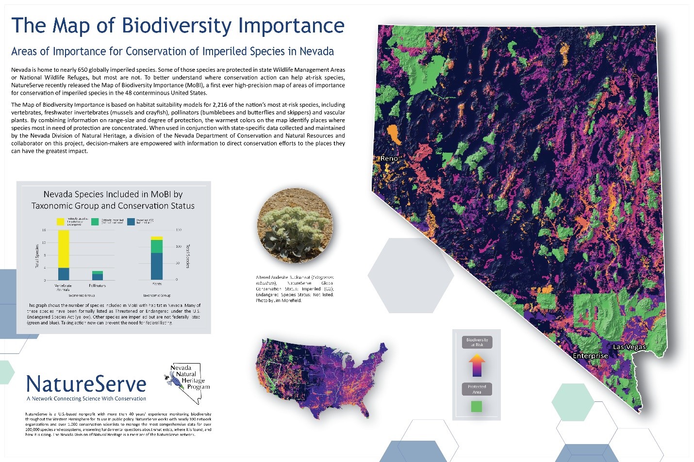
Nevada Map of Biodiversity Importance (Protection-Weighted Range-Size Rarity for Imperiled Species Summed for All Species) Inputs for the map include habitat models for species listed as Endangered or Threatened under the Endangered Species Act or those that have been identified by NatureServe as Critically Imperiled (Global Conservation Status of “G1”) or Imperiled (“G2”). The Map combines information on four taxonomic groupings (vertebrates, freshwater invertebrates, pollinators, and vascular plants). Data for these species is combined into an index representing protection-weighted range-size rarity for imperiled species.
The brightest colors on the map reveal where multiple imperiled species occur outside of the lands and waters that are already designated for conservation, with an emphasis on species with small range sizes and thus fewer conservation opportunities. This information can be used to inform public-private partnerships such as Candidate Conservation Agreements and Habitat Conservation Plans.
To view the state map online, visit heritage.nv.gov. A full view of the national Map of Biodiversity Importance can be found on NatureServe’s Hub site or Esri’s ArcGIS Living Atlas of the World.